Resolving Issues with GPS Locations in GIS
April 23, 2018
Use of GPS-enabled devices and applications is now more widespread, with many of us making use of GPS technology on a daily basis without issues or much consideration. However, issues can be experienced when attempting to combine GPS-derived positions with traditional map data, such as Ordnance Survey datasets, within a mapping or GIS application.
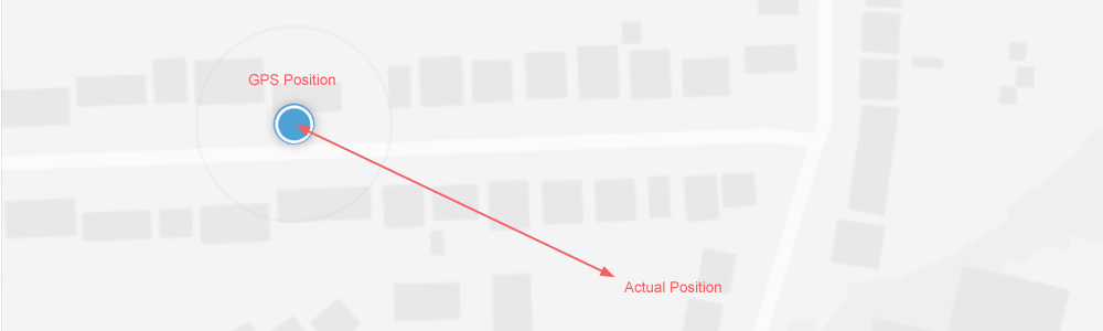
A regular enquiry we receive at GIS4BUSINESS involves issues with GPS locations displaying incorrectly, usually with a significant offset, when combined with other data within a mapping or GIS application. In a recent enquiry, a user was experiencing a positional offset of around 100m when attempting to collect features in the field using Collector for ArcGIS®, a mobile field data collection app from Esri.
In this article, we explain how to resolve issues with GPS locations by setting a transformation. In this case, the underlying map within the Collector for ArcGIS app was using an Ordnance Survey basemap and we were able to resolve the issue relatively quickly, because it relates to a fundamental element of all mapping and geographic information systems, the map projection or coordinate system.
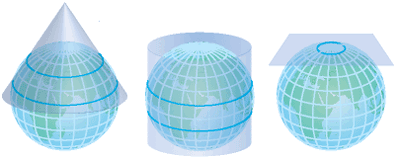
GPS is a global positioning system that records positions using latitude and longitude on a geographic projection that is based on a sphere (actually an ellipsoid), and specifically uses the World Geodetic System (WGS 84) coordinate system. In contrast, Ordnance Survey data uses planar coordinates (x & y) using what is known as a projected coordinate system, specifically British National Grid (OSGB 1936).
In order to translate between GPS coordinates (lat & long) and a planar coodinate system (x & y), such as British National Grid, a transformation is required which is based on a map projection. Some examples of map projections are shown below.
When using mapping and GIS applications, this transformation if often applied automatically by the software, based on the coordinate systems that are used in the map. In this case, in Collector for ArcGIS the basemap used for the map was based on OS data, so the software was applying a default transformation between the GPS coordinates (WGS-84) and British National Grid (OSGB-1936). The result was that the resulting GPS position reported in Collector for ArcGIS was over 50 metres from the known position, despite the GPS reporting sub 10-metre accuracy.

The following steps show how we were able to resolve the GPS issue within Collector for ArcGIS by applying a specific transformation, rather allowing the software to use the default. Although these steps are specific to Collector for ArcGIS and to using a map based on the British National Grid coordinate system, a similar approach to selecting a specific transformation may be required in other mapping and GIS applications, wherever GPS locations are shown on a map that uses a planar or projected coordinate system.
- Within Collector for ArcGIS click the menu in the top left (3 horizontal bars) and then click Settings:

- In the settings, choose Location and then click the Default Location under Location profile:

- On the Location Profiles pop-up, click Add a profile:

- In Add Profile, type “WGS 1984” in the search box and then click GCS WGS 1984 to select this as the receiver’s coordinate system:

- Next click Projected and then type “British National Grid” in the search box and click British National Grid to select this as the coordinate system used by the map:

- Click Continue on the expected area for data collection:

- Then select OSGB_1936_To_WGS_1984_Petroleum as the datum transformation. In our experience, this is the best general purpose transformation for the whole UK:

- Type a name for the profile (e.g. WGS84 to British National Grid):

- The location profile will be added – click the profile to enable the options:

- Click Switch to change to the new profile:

- The profile should now appear as “current”:

- Close the location profiles pop-up and the new profile should now display in the location settings. This transformation will now be used instead of the default:

The result of changing the default transformation in this case, using the above steps, can be seen below. The resulting GPS position now more accurately reflects the known position.

The concept of applying a suitable transformation is applies to most mapping and GIS solutions, including other Esri software, such as ArcGIS Desktop or the Esri Javascript API. If you find that your GPS position or GPS-derived data is not overlaying correctly on your OS base map, then it’s worth considering setting the transformation manually, rather than relying on the default transformation selected by the software.
If you require assistance with any of the above then feel free to contact us.
Related
Technical Support
Our flexible technical support agreements cover your organisation’s implementation of the software, business processes and data. We can also implement pro-active maintenance processes to ensure that your solution continues to perform optimally.
Esri Collector for ArcGIS
Esri Collector for ArcGIS®is a configurable map-centric field data collection app for Windows, Android and IOS devices. Collector for ArcGIS can operate in online and offline modes and supports external high-accuracy GPS devices for improved accuracy.
Esri ArcGIS Desktop
Esri ArcGIS® Desktop is the industry standard professional desktop GIS for managing and maintaining enterprise GIS data, creating and publishing maps and performing advanced spatial analysis.
Mobile GIS & Work Management Integration
GIS4BUSINESS assisted Portsmouth Water with the integration of their existing Esri enterprise GIS solution with IFS, a new corporate finance and work management system, including back-end and mobile GIS components.
Mobile GIS for the Field
GIS4BUSINESS provided technical GIS consultancy including feasibility, design and development as part of the delivery of a replacement mobile GIS solution for over 1700 field users within Severn Trent Water.
Mobile GIS Services
Using mobile GIS can streamline data collection and update workflows and provide timely information about assets, vehicles or resources. GIS4BUSINESS can help you make sense of the options and help design, configure and develop mobile GIS solutions.